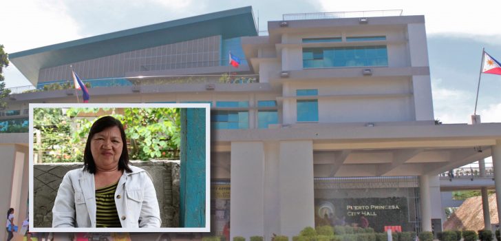
 Engr. Leonida Kho, Puerto Princesa City Project Engineer, discusses the emerging benefits of the PRDP subprojects in the city. She also shares some PRDP tools that the LGU will adopt for its regular projects. (Photo by Ana Francesca Chavez)
 Puerto Princesa City applies geotagging tool in implementing regular projects
Engr. Leonida Kho, Project Engineer of Puerto Princesa City, proudly shared that the city’s regular infrastructure projects will soon be compliant with the standards of the Philippine Rural Development Project (PRDP).
“Ina-appreciate namin ang mga natutunan namin sa PRDP. Kaya nga may instruction sa amin si Mayor Lucilo Bayron na unti-unti na naming i-adopt ang mga practices na natutunan namin sa PRDP (We appreciate what we are learning from the PRDP. That is why Mayor Lucilo Bayron instructed us to gradually adopt the practices that we have learned from PRDP),” Kho said.
Since 2014, the Puerto Princesa City Local Government Unit (LGU) has established partnership with the PRDP when it proposed the implementation of the “Concreting of Bukang Liwayway–Makandring Farm-to-Market Road (FMR).”
The 8-kilometer FMR located in Brgy. Langogan is the city’s first infrastructure development (I-BUILD) subproject under the PRDP. It is also the third PRDP FMR subproject to be completed in the MIMAROPA Region and in the South Luzon Cluster.
According to Engr. Allan Tatierra, PRDP South Luzon Project Support Office I-BUILD Component Head, the Puerto Princesa City is one of the most active and committed LGUs in the cluster when it comes to implementing FMR subprojects.
Mainstreaming the geotagging tool
Starting last year, the Puerto Princesa City LGU has been conducting training sessions on the use of the Applied Geotagging Tool (AGT) in its key offices led by the City Engineering Office. The city engineers were also given at least 10 geotagging devices.
Kho shared that during the LGU’s recent bidding for the concreting of city infrastructures, they said that the participating contractors should be PRDP-compliant or follow similar rules set by the PRDP.
“Ang isa naming requirement sa kanila na talagang nakuha namin sa PRDP ay nag-train muna kami sa mga contractor namin saka sa engineer ng geotagging para gaya nong mga ginagawa namin sa PRDP na naka-geotag lahat ng activities (One of our requirements to them that we have adopted from the PRDP is to train the contractors and the engineers on geotagging so that like what we are doing in PRDP, all activities will be geotagged),” she said.
At first, the LGU’s project contractors wanted to resist the new construction requirements. Now they have also trained their staff on geotagging. According to Engr. Kho, their subproject contractors also use the geotagging tool for other projects.
Kho admitted that the PRDP process and requirements were not easy for her and her fellow engineers when they started with the Project. “Ngayon sabi namin okay lang pala ’yong PRDP. Hindi na rin siya mahirap basta nasimulan mo na (Now we can say that [implementing] PRDP is manageable. It is no longer difficult once you’re with the Project already),” she explained.
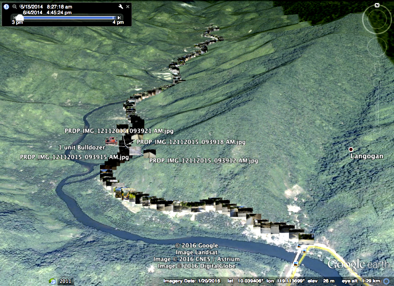
GEOTAGGED. Site photos for the “Concreting of Bukang Liwayway-Macandring farm-to-market road” sub-project in Puerto Princesa City are uploaded and placed on Google Earth for a more convenient project monitoring.
Transparency of projects
Through the AGT, subproject activities and accomplishments are documented with photos that are geotagged and uploaded online, which can be viewed using the Google Earth application. The PRDP’s use of this tool, which has enhanced security features that can detect illegal photo modifications, aims to promote transparency in project implementation.
According to Joseph Pacon of the Geomapping and Governance Unit of the PRDP’s national office, geotagged photos serve as documents that can be revisited to evaluate subprojects’ progress. In an earlier interview, he said that field monitoring and project evaluation can now be done online through the so-called virtual tour.
Geotagged photos are also used to verify materials specification and standards, post-qualification concerns, and causes of project delay before the release of subproject grants.
“Kami ngayon ay inu-unti-unti na naming maging sustainable na kahit mawala na ’yong PRDP nandoon pa rin ’yong mga good practices na na-adopt namin sa inyo (We now slowly transition to continue applying the good practices that we have learned from PRDP even after the Project has ended), Kho expressed.
Engr. Tatierra also emphasized the importance of another Project tool called the Infrastructure Quality Monitoring and Durability System or IQMDS, which can also be adopted by the city LGU to ensure the durability of infrastructures built.