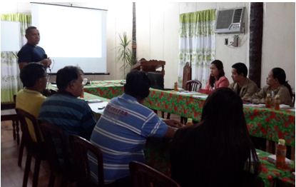
 Engr. Sam J. Bilamide (standing),Geo-Mapping and Governance Unit Head of the Philippine Rural Development Project’s (PRDP) National Project Coordination Office stressed the importance of geotagging as a transparency tool used in the project during the Training on Applied Geotagging recently held in Maasin, Southern Leyte. Participants of the training were contractors of PRDP subproject as well as some technical personnel from concerned local government units.
 LGUs, contractors undergo training on PRDP’s Applied Geotagging
Science-based tool geotagging was developed and first applied under the Mindanao Rural Development Program in 2011, resulting to a successful implementation.
Under the Philippine Rural Development Project (PRDP), winning contractors and local government unit co-implementers are required to regularly submit geotagged photos of the status of sub-projects as pre-condition for release of funds for payment.
“Essentially, geotagging is about the use of images for information – transmitting it the fastest way with utmost credibility,” said PRDP Geo-Mapping and Governance Unit (GGU) Head Engr. Sam J. Bilamide, during the Training on Applied Geotagging on March 10, 2016 in Maasin, Southern Leyte.
Belamide added that geotagging is one tool which could aid in decision –making, promote transparency in project implementation and ultimately, ensure proper use of government funds.
“This tool may be used for free. We can use it especially in validation and monitoringof sub projects and even in the process of assessment or evaluation. This will bring about savings in favor of the government as through its proper application, it will avoid, for instance, any possible duplication of funding support for any project, making full payment over unfinished or worse, non –existent projects,” he said.
During the training, participants were taught of the importance of geotagging under the PRDP, its application and the proper use of equipment. They were also required to conduct actual field-level geotagging.
Also present during the training were rural infrastructure engineers and technical personnel from the Infrastructure (I-BUILD) Component and GGU representatives from the PRDP Regional Project Coordination Office -8 and Project Support Office for Visayas. (Rodel G. Macapanas, InfoACE, RPCO-8)
