How To Guide – PRDP AGT Geo-tagging Camera Android Apps
PRDP AGT Geotagging Android OS Camera Application
The Geotagging camera apps was developed to facilitate proponent/user/contractor the ease of use of a digital camera without committing errors in the conduct of a geotagging documentation.
It combined the two(2) basic application in geotagging, the GPS status and the digital camera. If user forgot to enable the unit’s GPS, the application will notify first the user before starting the application.
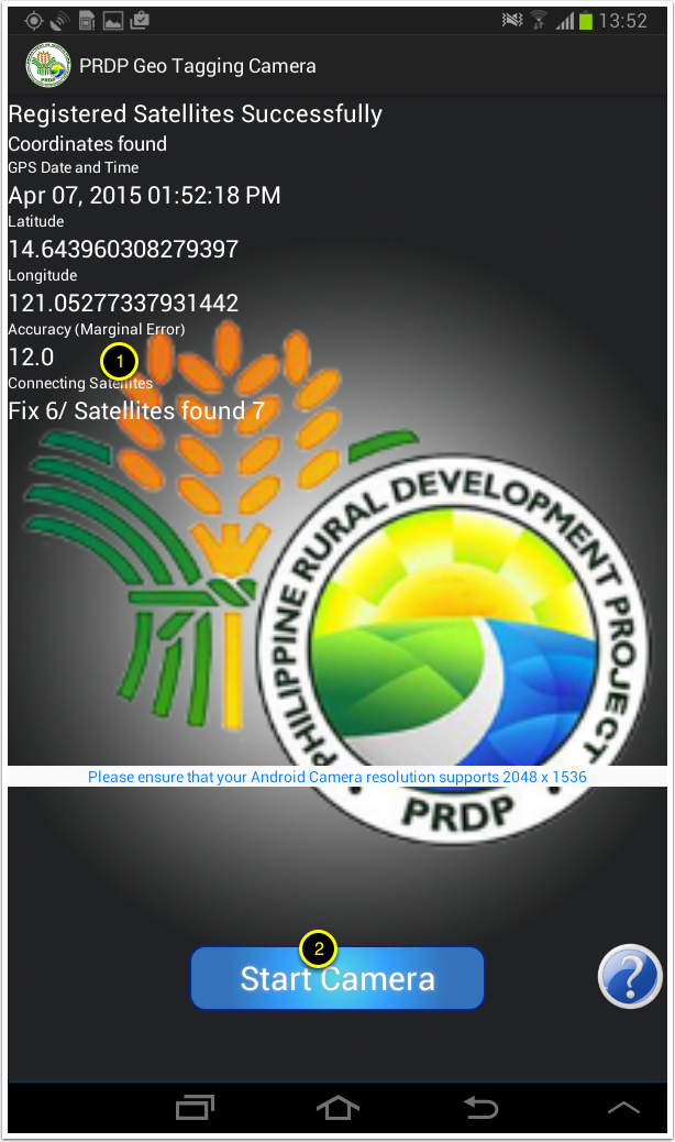
During Initialization the application will do the following.
- Obtain the GPS Date and time of the day, this is based on the GPS atomic clock and not the device system clock. The GPS Date and Time is always the correct date and time during the conduct of the geotagging documentation.
- Attain the AGT procedure allowable error. The DA PRDP AGT procedure established a recommended marginal error between 5-15 meters. The application cannot be started if allowable marginal error is not attained.
- The camera system recommend an android camera resolution of 2048 x 1536 pixel and above.
- When the PRDP AGT camera system attained the allowable marginal error, user (2) can start the camera.
The PRDP AGT Camera Graphic User Interface (GUI)
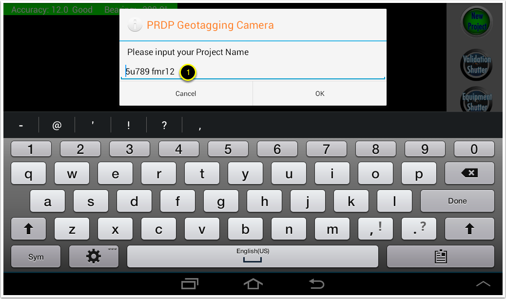
- Once started, the GUI will prompt user to input the project name. It is recommended to type the sub-project title then click “OK” to save
- When switching from MyTracks and the PRDP AGT Camera, this prompt will always show up prompting user that it is working on the same project title.
- This feature is designed if user is conducting 2 or more sub-project geotagging documentation in a day, geotagged photos will not mixed up on a single folder if sub-projects is given a different name or title.
The PRDP AGT Camera Shutters
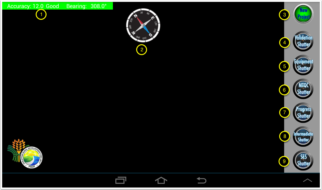
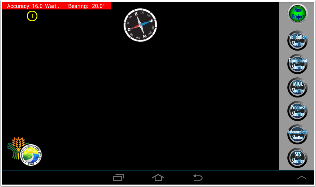
- Green accuracy indicators visually notify user that the device is within the allowable marginal error and user can take a geotagged photo with precise location.
- Bearing is an angular unit or measurement reckoning from the true north location in a clockwise direction. its tell the angular alignment the device is facing, or in FMR, its give the angular alignment of the FMR where the camera is facing.
- The compass augment the directional information. Not all android devices are equipped with digital compass, if you notice no movement of the compass, the unit does not have a digital compass embedded as a chip on the device. Digital compass is not a software that can be install, its a hardware.
- User can now switch to new project AGT documentation without geotagged photos mixed-up.
- Validation Shutter will be used in the conduct of project identification/validation and for new proposed FMR, taking four (4)geotagged photos at every 50 meters interval.
- Equipment Shutter will be used in taking contractors equipment at the project location site, this can also be use during BAC-TWG post-qualification in inspecting contractors equipment, but for mobilization billing, equipments must be geotagged at the project location site.
- MTQC Shutter will be used during construction phase were contractors will be doing MTQC activities.
- Progress Shutter will be used during construction phase taking four (4) photos at 50 meters interval for FMR at each item of work based on SWA.
- Intermediate Shutter will be used during project ID/validation showing proposed structures between the 50 meters interval. Same shutter will be used during construction phase of the same proposed structures.
- SES shutter will be used for SES related mitigating measures, sometimes “intermediate shutter” is also a SES related mitigating measures.
- The PRDP Logo GUI Overlay (Just a Bragging Rights) copyrights
1. If user attempted to take a geotagged photos with red accuracy indicator, the camera system will prompt the user and will not save the photo.
Post-processing and Geotagged photos location
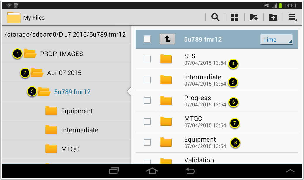
- Using the PRDP AGT Geotagging Camera Apps, photos are save per project during the date the AGT documentation conducted. It created a folder under the directory DCIM/PRDP_IMAGES
- Created a sub-folder the date the PRDP AGT geotagged photos was taken
- Created a sub-folder the title of the project or sub-project
- 4,5,6,7,8 are the location of the geotagged photos of each shutter used.
- these are all done onthefly by the PRDP AGT Camera Apps for preparation in uploading to picasaweb and subsequently overlaying its generated KML file into an interactive map using google earth pro.


