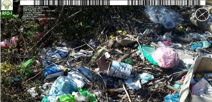
 Monitoring Waste Management. The above image is an example of a geotagged photo monitoring waste management in the barangays of Currimao, Ilocos Norte.
 Geotagging used for monitoring waste management in Currimao, Ilocos Norte
The Philippine Rural Development Project (PRDP) has introduced geotagging technology as an innovation in promoting transparency and accountability in its funded subprojects. Geotagged pictures, which are code encrypted, enables real-time monitoring of enterprise and infrastructure subprojects. They contain information such as the exact location, time, and place where the pictures were taken.
In the Municipality of Currimao, geotagging is recently used, not only in monitoring the progress of PRDP subprojects but also, in monitoring waste management in the barangays.
In 2015, Engr. Erickson Biag who is the Municipal Agriculturist and the acting Municipal Environmental and Natural Resources Officer attended a training on using the geotagging technology under the PRDP. In the same year, the Municipality of Currimao started the preparation of Currimao’s infrastructure subproject, the Rehabilitation of Tapao-Tigue-Sta. Cruz, Poblacion 2-Lang- ayan Farm to Market Road.
Upon usage of the application in the PRDP subproject, Engr. Biag saw its potential in monitoring other municipal-led projects. In 2016, he decided to use geotagging in monitoring waste management under the Municipal Basura Patrol Program. This municipal-led environmental program complies with Republic Act 9003 or the act providing for an ecological waste management program. He said that through the geotagged pictures, barangay officials cannot deny the incidence of improper waste management in the community.
The results of the waste management monitoring through geotagging are presented in the Municipality’s Multi-Council Meeting which is held once every quarter. The meeting is attended by school heads and representatives of other national government agencies. Engr. Biag said that meeting attendees had been curious how geotagging works.
Engr. Biag further said that the incidence of improper waste management in Currimao has significantly decreased through the use of geotagging in monitoring waste management. Since the pictures can pinpoint where improper waste management takes place, the Municipality’s environmental office easily takes action to coordinate with the community. The Municipal Council will task the barangay which has an incidence of improper waste management to clean their community.
Also according to Engr. Biag, the Municipality plans to create a map of all government projects in Currimao using the geotagging technology. With this, duplication of government subprojects in the Municipality can be avoided.
PRDP’s tools, like geotagging, aim to permeate mainstream government projects for transparency and accountability. In fact, the geotagging application used by the Municipality of Currimao in monitoring waste management in the barangays is that of the Department of Agriculture.
Geotagging is indeed an innovative tool in project monitoring and promoting transparency and in government projects. At present, its usage, worth, and potential is slowly being recognized beyond PRDP. ### (Dessa U. Estrada and Vida Cacal, RPCO1 InfoACE Unit)
