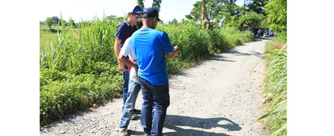
 Mr. Sam Belamide gives hands-on training on proper geo-tagging of FMR in Oriental Mindoro. Aside from farm-to-market roads, geo-tagging can also be used to monitor other government projects like reforestation, animal (or other subsidy) dispersal, infrastructure construction and more.
 More gov’t agencies use geo-tagging
AFTER proving the effectiveness of geo-tagging on the projects implemented by the Mindanao Rural Development Program (MRDP), other Philippine government agencies are slowly beginning to adopt the technology in their projects.
Department of Agriculture (DA) pioneered the use of geo-tagging in ensuring that MRDP projects keep up with the standards and promote transparency and accountability in the disbursement of funds.
Geo-tagging is a web-based technology that makes use of attaching location-specific information like GPS coordinates to pictures, videos, and SMS messages.
“The best practices we learned from MRDP, we adopted it to our regular programs,” said Edilberto M. de Luna, DA assistant secretary for operations, during a press conference at the Davao Convention & Trade Center Thursday.
He said they did not only learn to apply the use of the technology in monitoring farm-to-market roads but also in other projects like post-harvest facilities.
Carolina Figueroa-Geron, World Bank task team leader for the Philippine Rural Development Program (PRDP), said geo-tagging earned good following from other agencies after seeing MRDP and DA reap the benefits for adopting it.
Among them are Department of Environment and Natural Resources (DENR), Department of Interior Local Government (DILG), Department of Education (DepEd), National Irrigation Administration (NIA), and Department of Social Welfare and Development (DSWD). These agencies have used geo-tagging in their infrastructure projects.
Geron also said that DA is now spearheading the training of the use of geo-tagging to government agencies.
“Geo-tagging is now a requirement by the Department of Budget and Management (DBM) prior to the release of rural infrastructure and post harvest projects,” De Luna said.
He added that the tool promotes accountability and transparency in project implementation.
“Besides promoting transparency and procurement reforms, it also promotes and facilitates the policy of decentralization and more effective service delivery because the national government now is able to monitor and evaluate the resources it courses through to local government units,” said Felizardo K. Virtucio Jr., World Bank Task Team Leader for MRDP 2.
MRDP program director Lealyn A. Ramos said even the public will be able to monitor the geo-tagged projects through the internet. For example, she said the public may check the website of MRDP or PRDP to check on the projects that are being implemented.
MRDP Deputy Program Director Arnel De Mesa said in the MRDP projects, they were able to stop sub-standard projects before more money was wasted through the use of the technology. He said they were able to save up some P300 million by stopping these projects.
Source: http://www.sunstar.com.ph/davao/business/2014/09/25/more-govt-agencies-use-geo-tagging-367607
