PRDP’s geotagging app a game changer in virtual monitoring of project progress
CAMALIG, ALBAY – The Philippine Rural Development Project (PRDP) continues to be a game changer despite restrictions to curb the spread of COVID-19. This is by intensifying the use of its applied geotagging tool (AGT), developed by the Project’s Geomapping and Governance Unit (GGU), which now comes with a new feature—geovideo in monitoring infrastructure development (I-BUILD) subprojects.
According to PRDP-Bicol Geographic Information Systems (GIS) Officer Engr. Philbert Nebres, while enhanced and general community quarantine (ECQ) are still in place, virtual validation of I-BUILD subprojects is a practicable solution in the absence of physical validation.
“Malaking bagay yung geotagging kasi through virtual submission, through e-mail, mga ICT – yung project ongoing. Nai-ensure naman yung quality ng project because every item of work dino-document sya through geotagged photos and also may geovideo na rin (Geotagging is a big help because through virtual submission through email and other ICT, projects are still ongoing. We can ensure project quality because every item of work is documented through geotagged photos, and we now have the geovideo),” Nebres said.
Nebres added that using the AGT, the Management get to see the actual progress of construction activities on-site. Currently, the GGU team has already rolled out the geovideo feature in conducting site inspections while PRDP guidelines in using it is still in the works.
PRDP-Bicol Deputy Project Director Adelina Losa agreed saying that it keeps the Management updated about the actual status of the subproject.
“Ang geotagging is a very good tool especially in monitoring… Kapag nag-geotag baga mahihiling ang status as if garo man sana ika nagduman (Geotagging is a very good tool especially in monitoring… Through it, you may view the project status as if you are in the actual location),” Losa said.
PRDP-Bicol Rural Infrastructure Engineer (RIE) Joel Catimbang said that the geovideo is an efficient tool in validating the accomplishment status or progress of I-BUILD projects being monitored.
“Napakalaking tulong nun lalo na ngayon na may COVID-19 tayo. Maiiwasan natin yung mga (physical) contact, pakikisalamuha sa maraming tao. Dahil dun sa geovideo, yung nagmo-monitor sa malayo parang real-time nilang makikita kung ano ang ginagawa sa field and kung paano ginagawa (It is a big help especially now with the threat of COVID-19. We can avoid physical contact and face-to-face interaction with many people. Using geovideo, monitoring staff may view actual field activities and how they are being done),” he said.
He added that the geovideo comes with a mapping feature and can calculate the distance traveled during site validation. This gives RIEs like Catimbang an idea of the project’s actual physical accomplishment. It also allows them to look into minute but essential details of the construction activities such as conduct of field density tests.
“Kasi may instances na parang pinicturan lang for the sake na maipasa, hindi pala ginawa. Sa geovideo makikita na ginagawa talaga yung requirements na yun. Sa quality, ang tumitingin dito halimbawa sa World Bank or NPCO, parang nandoon sila sa field. (Because there were instances that photos were just taken for the sake of passing it off as if it was already done, without actually doing it. With geovideo, we can ensure that requirements are being done. World Bank or NPCO officials may check whether quality standards are being followed as if they are in the field),” he furthered.
Geotagging is the practice of associating digital resources like photos, website, short message service (SMS) with a physical location. PRDP’s GGU developed AGT, a remote or online subproject management tool using freely available location-based technologies. Using the AGT android app, geotagged photos may be taken and markings may be embedded against digital modification. This provides precise location of the subproject, its nearest route from the proponent or implementing local government unit, and its relationship to influence areas as well as existing establishments or infrastructures. The innovative tool is also designed to support subproject supervision, monitoring and quality monitoring.
Virtual site visits will be adopted for the 10th World Bank Implementation Support Mission to PRDP South Luzon Cluster scheduled in June 2020. Virtual site visit will be conducted for road access and vertical structures using videotags of infrastructure development (I-BUILD) subprojects showing their progress implementation and ongoing construction. (Annielyn L. Baleza, DA RAFIS V with reports from Engr. Philbert M. Nebres, PRDP Bicol GIS Officer and Engr. Joel A. Catimbang, PRDP-Bicol Rural Infrastructure Engineer)

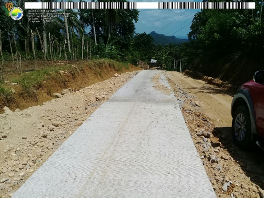
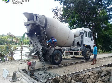
Photos taken during the I-BUILD team’s project site validation at the Concreting of Manangle – Caima FMR in Sipocot, Camarines Sur, Upgrading of Cuco-Bagong Silang FMR in Pasacao, Camarines Sur, and Road Opening and Concreting of Batang-San Gabriel FMR in Pamplona, Camarines Sur.
Photo Credits: Engr. Joel A. Catimbang, PRDP-Bicol Rural Infrastructure Engineer