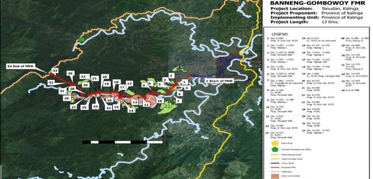
 Sample project map of the I-BUILD subproject ‘Improvement of Banneng-Bawak Farm to Market Road’
 Geomapping and Governance Unit – Putting innovation into practice
The systematic use of innovation paved way for transparency, accountability and cost-efficiency in the implementation of the Department of Agriculture’s Philippine Rural Development Project (DA-PRDP).
Through the Geo-mapping and Governance Unit (GGU), the Project widely promotes innovation in reviewing and monitoring subprojects. The unit is mainly designed to institutionalize science-based project tools such as Vulnerability and Suitability Assessment (VSA), Expanded VSA (e-VSA), Geo-mapping, and Applied Geo-tagging (AGT).
Said tools greatly aid the project and its implementers in determining whether a proposed sub-project is implemented in the right place, while promoting cost-effectivity through virtual monitoring of sites and equipment.
“The work we are putting on GGU brings a lot of benefits,” said World Bank Task Team Leader Frauke Jungbluth during North Luzon’s leg in the World Bank midterm review mission.
Frauke lauded the unit for the continuous development and improvement of the tools.
She added, “You are (in) the front line of doing this and many others are now thinking about (replicating) this as a program for the Philippines.”
To maximize the use of the Geo-tagging technology, the unit participates in various activities that require the use of the tool along with other components and units.
One of these is the formation of the Joint Inspectorate Team (JIT) along with the Social and Environmental Safeguards Unit and I-BUILD component. This activity is being regularly conducted to validate the completion of reported activities of ongoing infrastructures.
“For the year 2017, the GGU of the cluster participated in 71 JIT activities on the ongoing I-BUILD subprojects,” said Project Support Office (PSO) GIS Data Specialist Jay Herrera.
He further reported, “GGU has improved and harmonized their Applied Geotagging Technology (AGT) and geotagged photo requirements with the COA circular compliances. Also, we modified some minor changes with their AGT Certificate in working hand in hand with the Finance Unit.”
One of the major activities that require the use of geotagging is the Rapid Appraisal Emerging Benefits (RAEB) in which the unit validates selected farmer respondents and their farm areas prior to the individual surveys and interviews done by other components and units.
Another activity is the Citizens Monitoring Training (CMT). With this, CMT members and the public will now have interactive information on PRDP subprojects, and can easily send report or feedback using GeoSMS or geotagged photos.
Good practices
For easier visualization of the connectivity between I-BUILD and I-REAP subproject, GGU produces connectivity maps and project maps, usually displayed in the actual SP sites. This showcases the project’s goal of providing enterprise opportunities to rural farmers while creating linkages between the farm areas to the markets.
In addition, PSO GGU practices transparency by requiring all contractors to post geotagged photos in their bunkhouses for accessible monitoring and comparison of monthly progress.
In the Regional Project Coordination Office 1 (RPCO1), GGU has developed an offline tool called the Geodata Organizer which “stores geotagged photos, sorts them by month, year, and segment, and can compare images by station,” according to RPCO1 GGU Head Deo Rivera.
As more subprojects are now simultaneously being rolled-out, innovation plays a vital role in complementing the manpower of the World Bank-funded Project. ### (Kayla Arceo, PSO InfoACE)